Object
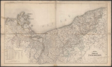
Title: Karte von der Provinz Pommern
Description:
Publisher:
Publication Place:
Language:
Resource Identifier:
oai:zbc.ksiaznica.szczecin.pl:50159
Source:
online catalogue:
Original Localization:

Object collections:
- Digital Library > 1. POMERANICA > Cartographical documents
- Digital Library > 2. CULTURAL HERITAGE > Cartographical documents
Last modified:
Mar 14, 2025
In our library since:
Apr 22, 2022
Number of object content hits:
172
All available object's versions:
https://zbc.ksiaznica.szczecin.pl/publication/52675
Show description in RDF format:
Show description in OAI-PMH format:
| Edition name | Date |
|---|---|
| Karte von der Provinz Pommern | Mar 14, 2025 |