Object
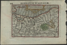
Title: Pomerania
Contributor:
[Bertius, Petrus] (1565-1629) ; Keere, Pieter van der] (1571-1646). Ryt.
Description:
Publisher:
Publication Place:
Language:
Format:
Resource Identifier:
oai:zbc.ksiaznica.szczecin.pl:1767
Source:
Relation:
online catalogue:
Rights Management:
Original Localization:
Biblioteka Główna Uniwersytetu Szczecińskiego

Object collections:
- Digital Library > 1. POMERANICA > Cartographical documents
- Digital Library > 2. CULTURAL HERITAGE > Cartographical documents
- Digital Library > Zasób Uniwersytetu Szczecińskiego
Last modified:
Jan 8, 2013
In our library since:
May 12, 2009
Number of object content hits:
197
Number of object content views in DjVu format
177
All available object's versions:
https://zbc.ksiaznica.szczecin.pl/publication/2118
Show description in RDF format:
Show description in OAI-PMH format:
| Edition name | Date |
|---|---|
| Pomerania | Jan 8, 2013 |